Juliana Trail, 330 km (2025)
An unexpectedly beautiful trail designed to prevent overcrowding on Triglav mountain
Bright blue rivers like you only see in advertisements, green hills, sharp peaks and bunkers and trenches from the First World War. The Juliana Trail offers a variety of beautiful moments. The main route circles the Julian Alps for 270 km, staying mainly in the valleys. A 60 km extension takes you into the Brda wine region. It's not a particularly difficult or technically challenging trail, and despite the elevation changes, there's no scrambling anywhere. Only the heatwave makes it challenging.
Day 1: Solkan – Korada, 24 km
Figures. Just when I travel to Slovenia to hike, a heatwave is taking off. Yesterday, late in the afternoon, when I walked from the small train station with a single platform to the hostel, it was 31 degrees Celsius. That's why I'm starting early today, at 5:30 AM. Back to the station, where the parking lot is larger than the platform. There are cars, rental bikes, and a repair station with all kinds of tools. There are also information boards about nearby hiking trails: the Walk of Peace, local tours. The Juliana Trail isn't among them. However, at the end of the parking lot, there's the first, clear marker on the town sign. I follow the road to the bridge over the Soce River, at a quarry spanned by a beautiful stone bridge with arches, nestled among the green hills. The route follows the road for a while and then begins to climb. A steep climb. Not even half an hour into the hike, sweat is already dripping from my forehead, despite the cool shade of the forest. I hoist myself up with my trekking poles, step by step, for two kilometers. The foliage grows lighter, the path easier. I arrive at the ruins of a church, St. Valentine's, destroyed during the fierce fighting between Italy and Austria-Hungary in World War I. The Isonzo front, named after the Italian name for the Soce River, ran right across this ridge. A vase of plastic flowers stands on the altar. I walk into a side aisle, from where I have a beautiful view of the valley with its green fields, villages with charming houses, and that lovely, winding river. On a wall lies a single trekking pole that someone has forgotten. Oops! You really need one here. From the church, the route follows the Sabotin ridge, a stony path where I have to watch my step. I'm now walking directly in the sun, and despite the early hour, it's already quite warm. A pillbox appears before me, a concrete bunker with small firingholes. Later, I see carved caves that housed troops during the war and from which grenades were fired. Then the route descends briefly into the woods and there are trenches. So different from those in Ypres, Belgium, where I've been three times now. Those were dug in mud and earth, with wooden planks to support the ground. This is rock and stone. How much effort it must have taken to dig out this entire network. A bit further on, I come across a second set of trenches, overgrown with bushes and shrubs. So close together. Were they both Italian, or was the front line really that close together?
I meander further along the ridge and, except for a few short stretches through lower forest, I walk fully underneath the blazing sun. The path is rocky and the going is slow. I carefully puzzle over where to put my feet. My trekking poles scrape against the rocks. Once, I see a large snake dart away, but it's too fast for me to see clearly. There are more remnants from the Great War: a stone pyramid, one of seven built in 1920 to mark the front line during the Sixth Battle of Isonzo. Pillboxes and concrete bunker ruins. In one of them, the name of the Italian regiment is inscribed in the concrete. How extraordinary. To my right, the Soce River meanders between the green valleys, far below, a road alongside which I sometimes hear engines. The sky is a deep blue, and in the distance I see villages with church towers rising above the houses. I've been longing for a break for a while, but I want shade. Finally, I find a spot by a weathered and barely legible information panel where it's a few degrees cooler, and I take off my backpack. I grab a snack and refill my small water bottle from the liter bottles on the side of my backpack. Of the 2.5 liters I started with, I'm down to 1 liter. And that after 5 kilometers. Fortunately, it continues downhill from here, and I always drink less on descents. And the path continues through the forest, where slender trees cast wonderful shadows. The amount of stones on the path diminishes until I finally reach asphalt. I faithfully follow the markings, but somehow something goes wrong. The Solkan – Smartno and Smartno – Korada routes are close together, and somehow I end up on the Smartno – Korada leg. Unsuspectingly, I follow the markings to the village, where I arrive about 1.5 kilometers early. There's also supposed to be a side path to a remarkable church from 1500 with one of the first Gothic altars in Slovenia. But because I'm on the wrong path, I don't get anywhere near it. I even almost miss Smartno. After all, past the bike rental shop, there's a yellow paint stripe on the road. Still, I don't quite trust it and turn back. Smartno turns out to be a small, walled village that's really no bigger than it looks. Through the gate, I enter the beautiful village with its cobblestone streets and neat, white houses. There's one café, a wine bar with a covered terrace, chairs with soft cushions, and a beautiful view of the valley. I plop down and buy two cans of Coke inside, which I quickly down. It doesn't seem appropriate to make my own lunch here, so I stick to two granola bars. After forty-five minutes, I put my backpack back on, but stop briefly in the square to refill my water and dip my head under the public tap. Ah, that's nice. I follow the markings back to Imenje, and then I get a sneaking suspicion. Haven't I already walked this route? With GPS in hand, I try to figure out exactly where I went wrong. Despite checking and puzzling regularly, I can't figure it out, and it's far too hot to think. After a kilometer or two, I come across the monument to the war of independence, in which Slovenia gained independence from Yugoslavia in 1991. The flags above anti-tank blocks, which were actually used in the war, flutter proudly. A little further on, the turnoff to Korada appears, and I'm glad for a new route. The path dives into the forest and winds occasionally across the road and occasionally through the forest towards Korada.
I slowly start to feel unwell. Nauseous. At a church, I dunk my head under water again, even though my hair dries far too quickly in this heat. An hour later, I lie down on a bench in a cool, whitewashed bus shelter. My pace slows, but I keep going. It's not far now. Still 3 kilometers to go, 2.3. One of the other red signposts tells me how long to the hut, and that gives me courage. Just 35 minutes, 20. Just before the final climb, I rest briefly, but as I stand up, I throw up. Nothing but water comes out, and afterward, I feel a little better. The route enters the forest, and although the climb is tough, I take it easy and manage. With 900 meters to go, I stop again and throw up again as soon as I stand up. My body doesn't handle heat well, I know that. And yet, I hadn't expected it to be this hot. I don't have any electrolytes with me, I've never needed them on my previous hikes. But yes, those were in Sweden, Iceland, and Greenland, where it's much cooler. Besides, I don't like them. I'm not wearing a hat either, because it’s much too warm on my head. Time to put my preferences aside and do what my body so clearly tells me it needs. I crawl doggedly on, step by step. Then, through the trees, I see the clean lines of the hut. Finally, I'm there. I buy a can of Coke and plop down in one of the beach chairs with a fantastic view of a valley and the mountains beyond. Unfortunately, the hut is only open on weekends, and I can't sleep there tonight. So I've ordered a shuttle to take me back to Smartno, where there's a small hotel. I've booked the taxi for 5:00 PM, plenty of time, I thought. I'd mentally prepared myself to spend a few hours at the hut. But I don't reach it until 4:40 PM. Gosh, if I'd taken the correct route, it would have been longer and I would have missed the shuttle! A blessing in disguise, then. And the shuttle is even too early; at 4:50 PM, a young man arrives, unwilling to drive the last stretch to the hut in his roadcar; the road is too bad. Luckily, he picks up my backpack, and I only have to carry my shoes and camera, as I've already changed into sandals. He drops me off right at the hotel door and even carries my backpack inside. A cold shower later, I feel a bit better, but when I try to eat something later, even a salad only goes halfway down. That will be something tomorrow. Luckily, the distance tomorrow will be shorter, and there's a small convenience store along the way, just before the biggest climb of the day.
Day 2: Korada – Planinksi dom pod Jezo, 21 km
It's Vesna, the shuttle driver, who suggests it. "I'll pick you up tonight anyway, why don't you leave some luggage in my car?" A brilliant idea, and with a very light backpack, I'm back at the Korada hut. It takes a bit of searching for the first trail marker, but once I spot it, I have no more doubts for the rest of the day. The route leads into a grassy field over the hills, with views of rolling mountains on both sides. I'm not feeling quite right yet. I barely ate yesterday, a light breakfast this morning. But no salt, and I quickly feel nauseous. Fortunately, the route dips into the forest, where the shade is wonderfully cooling. When I emerge from the forest, I throw up unexpectedly. Yuck. That was my breakfast. Apart from my stomach, I actually feel pretty good. My legs are still working, and I've even dug up my ice towel, which is wonderfully cool. The route follows a paved road for a while, passing rolling fields full of flowers, and just as I'm starting to have doubts, I come across another signpost at a Maria chapel. The road climbs to a church, where I'm not so much interested in the history, but in the tap at the cemetery. No drinking water, unfortunately, but it's nice and cool on my head. I slowly stroll on towards the village, where the guidebook has promised me a small shop. When I see the first houses, I’m not so sure. This isn't a village, but a hamlet. And indeed, no shop in sight. There is a house with what might once have been a shop, but I don't need to read Slovenian to know that the sign on the front door means "closed." That's a bummer, what now? At a house, I plop down on the terrace in the shade. The resident comes out and offers me tonic water. It's disgusting stuff, but I drink it. A moment later, she insists, and I ask for salt and yogurt. She brings something even better: electrolytes and a drink yogurt. Just what I needed. I lie stretched out on the terrace for about an hour and a half, my seat cushion underneath my head. Every ten minutes, I drink some yogurt and electrolytes, and that helps enormously. Even the weather cooperates; clouds are rolling in, blocking the piercing sun, and a pleasant breeze is picking up. At two o'clock, I realize it's time to move on. I've postponed the shuttle an hour until 6 p.m., and I can easily make it, but only if I actually start walking. Rested and refreshed, I put my backpack back on. I thank the woman, but she's busy on the phone. I walk out of the village to a grassy path and then start climbing. And that's much less bad than I'd imagined. It's slow but steady, and after a good half hour I'm already at the top. There's no recognizable summit with a panoramic view, just a small stretch of flat ground where the route stops climbing and the next marker points downhill again. The route winds on, over overgrown jeep tracks and asphalt. At the next village, I deviate briefly to the church, but alas, there's no cemetery and therefore no tap. Disappointed, I continue walking, but then, outside the village, I finally see the walled cemetery. I don't see a tap, but the striking green watering cans beside it call to me. I wet my hair and the ice towel again and prepare for the final stretch. With only 700 meters to go, I take a break along the road at a bridge. I try a granola bar, but can only manage half a bar. Feeling a bit refreshed, I pull myself together. The route continues along the road, and a little later I arrive at the hut, which, as expected, is closed. Lizards crawl along the walls of the driveway, but they're too fast to photograph. Next to it is a small patch of grass with my name on it, and I stretch out comfortably, waiting for the shuttle. This was a good day after all.
Day 3: Planinski dom pod Jezo – Tolmin, 13 km
On the way to the pass, we see a young fox lying on the road. He seems healthy, probably just enjoying the warm asphalt. We also see a surprising number of hikers making the trek to the summit. Vesna drops me off at the hut, and we say goodbye. She's involved in organizing the Juliana Trail, and it was nice to get a behind-the-scenes look. But I'm here to hike, and as soon as I've started my GPS, I set off. The route immediately begins to climb, quite steeply. I slowly hoist myself up using my trekking poles. There's no clear summit with a view; surrounded by trees, the route winds up and down. But it's forest, and I'm glad of that. I end up on a cart track, take a short stretch of asphalt, and then dive back into the forest. Then there's open fields and a magnificent view of the surrounding mountains. I follow the signpost to a rifleman's nest and a trench that crisscrosses the mountain. There's also a trench with wooden supports and a roof above it. This must be Kolovrat, the open-air museum about WWI. I no longer see any Juliana Trail markers, but I take a long look around at the reminders of war and violence. The trenches lead me to the "entrance," a small shack with souvenirs and Coke. There are several benches under the shade of trees, and I sit down, opposite a few sweaty hikers who are taking off heavy backpacks. It turns out they're participating in a walking event, the Highlander, a 100 km trek in five days. About 150 people walked the shorter 60 km version, and 40 are on their way today to complete the 100 km. After a short break, I cross the road to begin the long descent. The path is a bit rocky in places, but it's not too bad. I'm able to cheer up the first hikers who come towards me with the news that they're almost there. A bit lower, I have to answer the same question differently: "You're not even close," which they laugh heartily about. The field of hikers is spread out, and an hour further down, I encounter hikers, the last three Japanese who, just to be sure, ask if they're on the right path. Once I've left the hikers behind, I come to a stream, which I follow downwards. The babbling water is a wonderful sound to have beside me. Oddly enough, there's a small stile in the route, right over the stream. As if cows would come here? Just before I emerge from the forest, I take a quick break, something I try to be mindful of in this heat. Refreshed, I step onto the paved road that will take me first to Volce and later to Tolmin. The first village isn't very large, and I pass through it quickly, after which I have a good view of the valley with its green mountains and the town nestled against its slopes. First, I pass a church, where green watering cans promise a water tap from afar. I dip my head under the water again, wonderfully refreshing. Also noteworthy is the vending machine next to it where you can buy votive candles, not drinks or snacks. I've never seen that before. The road takes me lower and lower, right along the Soca River, where a campsite sits on the green banks and countless people are swimming. In Tolmin, I wanted to do an extra hike to the Tolmin Gorge, which the guidebook recommends as one of the most beautiful gorges in Slovenia. But that excursion will have to wait. I can't resist the clear water and take off my shoes and socks. The riverbed is rocky, and I regret throwing my sandals away yesterday. Yes, the soles were torn and the rubber was coming off in chunks, but I could have used them now. When I lower myself into the water, fully clothed, it's freezing. Jeez… With such clear water, I wouldn't have guessed it would be a glacial river, but the water is just as cold. After about half an hour, I put my backpack back on and continue. My clothes are still wet and will keep me cool for a while. I follow the waymarkers to the bridge, from where I have a fantastic view of the river. I've never seen such clear water meandering towards the horizon in such beautiful surroundings. How special! On the other bank, the route dips into a forest path along the water, and I keep an eye out for the nice swimming spots so I don't have to walk all the way back to the campsite later. At a church and a cemetery, the Juliana Trail reaches the edge of Tolmin. I cross the ring road and walk past a supermarket to the center, where my hostel is located. After a short rest and some groceries, I prepare to walk to the gorge. After almost 500 meters on the warm pavement, I stop. What am I doing? It's far too hot. I want to swim. I turn around and walk back to the river, where I've spotted a perfect swimming spot with a soft gravel bottom just before a wooden café in a ruin. I sink back into the water and don't get out for the first hour. It remains freezing cold, but after a few minutes, it's not so bad. After about an hour and a half, I reluctantly walk back to the hostel and finally begin the short hike to the Tolmin Gorge. There's a parking lot on the edge of town, and from there, a marked hiking trail leads to the gorge. You can buy a ticket until 7:00 PM. And it turns out I was right to go a bit later in the afternoon. Not only is it much cooler, but I also have the entire gorge to myself. And it's breathtakingly beautiful. The clear water, the many shades of blue and brown of the stones and rocks, the way two rivers meet. This gorge sets the bar for all other gorges. After an hour and a half, I've explored the entire gorge and emerge through an iron turnstile onto the road, which I follow downhill, back to Tolmin.

Day 4: Tolmin – Kobarid, 17 km
Today I'm finally starting the big circular walk around the Julian Alps. No more shuttles, no time pressure to get anywhere. Now I can truly relax. From the hostel, I walk back to the Soca, but just before the river, I turn off to a small industrial estate. In a flash, I'm out of the village and following a path along the foothills, following the river for a while. When I pass a campsite with an available water tap, I stick my head under the tap next to the people washing their breakfast plates. They laugh, but I love it, and in this heat, I really need it. A little later, I hear the river rushing, and if there's a side path, I descend until I see the emerald blue water flowing over the rocks. The temptation to jump in is strong, but I've only been going 5 km, and that's still far too early. The route veers away from the river and follows the highway past the villages of Volarje, Selice, and Kamno. There are many cyclists along the route, and Slovenian flags fly at houses. Today is a national holiday, Slovenian Nationality Day. On this day in 1991, Slovenia declared independence from Yugoslavia. The actual war of independence lasted only ten days, from June 27 to July 7, but Slovenian Independence Day is celebrated in December, commemorating the 1990 referendum, in which 88.5% of the population voted in favor of independence. Just before Kamno, I pass a cemetery and walk to the entrance to dip my head under the tap again. It still feels good. I walk around the cemetery and pause briefly at the low wall to admire a lizard, which quickly disappears somewhere between the stones. I follow a cart track behind a large monument. After a bit of searching, I see a path going downhill a little ways back It turns out to be a former Italian war cemetery. A large stone monument honors the fallen of the Emilia Bridgade. The fallen have since been reburied, and the monument is the only reminder of them. In 2018, the dilapidated monument was restored. After a short stop, I continue along a lovely forest path with mossy stone walls, which remind me of the low sheep walls in England. The walls look centuries old, and I wonder if they are protected as cultural heritage, as I believe they are in England. I enter another village, Smast, and take a short break at the bus stop, the only place that's somewhat cool. Before I set off again, I walk a short distance back to the public tap above a stone trough that almost every Slovenian village has. I wet my hair, and that cools my head enough for the last stretch to Kobarid. Slowly, the route curves back towards the river, and at a large parking lot, I suspect a swimming spot, but I first want to get to my hostel to drop off my backpack. The last part of the route climbs, until I'm high above the river. From the Napoleon Bridge, I have a beautiful view of the narrow gorge along which the road winds on the other side. It's a popular spot, with tourists coming and going to take selfies. I cross the river and see a break in the guardrail and a staircase leading down on the other side. A beach, perhaps? But no, the staircase leads to a pulley system used to transport something across, though I don't see the logic in that. The platform does offer a nice view of the river, and on the other side, I see people swimming. Passing under a viaduct painted with fish, I enter Kobarid, a clean village with narrow streets and a charming square. It's still too early to check in at the hostel, so I first buy an ice cream and then settle down on a terrace. An hour later, I enter the hostel, which is nice and clean, and above all, wonderfully cool. The air-conditioning is set so high it's almost cold. I take off my backpack and walk back to the bridge. A little further on, there's a break in the guardrail and a steep, stony path down. But there's a beautiful little beach with real sand, not those nasty stones that made it so difficult for me in Tolmin. I take off my shoes and socks and step into the water, clothes and all. It's incredibly cold, but once you get used to it, it's wonderful. I sink into the water and lie lazily on the riverbed, just barely able to grab the crisps I left on the beach. A wonderful end to a beautiful day.
Day 5: Kobarid – Bovec, 21 km
It promises to be incredibly hot again today, so I set off around 6:00 AM. Even now, it's warm, but also a bit stuffy, and I'm glad I didn't sleep in. I walk back to the bridge over the Soca River and cross the river, but not without taking a few more photos of the magnificent gorge, which I have all to myself at this hour. On the other side, I only follow the road briefly before being directed onto a cart track. At the edge of the forest, there's a rest stop with a refrigerator full of soda cans. I do have cash on me, but the smallest note is €20, and I regretfully continue without packing cold soda cans in my backpack. The path descends to the river, and thus begins one of the most beautiful sections of the Juliana Trail so far. It's rocky, scrambling, and sweating. Wonderful! I climb through the forest on a side path to a viewpoint. I no longer encounter any waymarkers and wonder if I'm on the right track, but as long as I keep the river on my left, I can't go wrong. Later, the official route rejoins from the left; that path to a viewpoint was the route, oops! Every now and then, trees lie across the path, and I crawl under one of them and feel pain in my right hip. Did I sprain something? Fortunately, the pain subsides somewhat and doesn't hinder my walking. The route remains difficult, but enjoyable. The view, the water, the rocks. A wonderful challenge. After a few kilometers, I cross a suspension bridge and on the other side, I'm sent onto a cart track. A few meters later, at a side path, I hesitate. Should I stay on the cart track or not? About six meters into the forest, I see a squiggle on a tree. When I walk towards it, it turns out to be a Juliana Trail marker. Fine, I much prefer a forest path to an easy cart track. I follow the path along the river, but hardly encounter any markers anymore, where they had previously been abundant. The markers I do see are old and worn, not the fresh paint strokes I've been used to. The path is also quite challenging, and erosion has taken its toll every now and then. It's manageable and not dangerous, but I wouldn't be surprised if the route has been rerouted. A good distance further on, there's a signpost, and the route from Kobarid does indeed rejoin from a side path. Oops!
When the path climbs, I'm a bit disappointed. It's time for a rest, and I'd hoped to be able to swim. But then I see an unofficial path down, where there's actually a small sandy beach. I carefully descend over the rocks and first take off my backpack, then my shoes and socks. After a snack and a drink, I walk into the water and sink in. Heavenly! A good half hour later, I'm eager to move on. I walk the last bit to the suspension bridge over the water, from where you have a good view of the river. On the other side, a gravel road begins that's very popular with mountain bikers. I encounter dozens of them, both electric and regular. There are also many lizards; I manage to photograph a few, but not as close as I'd like. Kilometers further on, there's a concrete staircase leading down to the water source described in the guidebook. Time for another break. I dip my head under the water, and it's so cold that my scalp hurts. Reluctantly, I drink the electrolytes I so desperately need in these temperatures and wash them down with fresh mountain water. I continue along the gravel road to Log Cezsoski, but apart from a water tap, there's nothing to be found among the few houses. A little later, I spot a hotel on the other side of the river. I cross the bridge, and although the signs promise a bistro and restaurant, the hotel is under construction and the bistro is understandably closed. Onward then, to the next village, Cezsoca. Initially, it doesn't seem much either, but on the outskirts there's an Outdoor Adventure company, and I take a chance. There's actually a fridge with drinks at the reception, and I immediately buy two cans of Coke. The owner invites me into the backyard, where a picnic bench sits in the shade of a tree. I really needed that. I down both cans in a row and stretch out on the wooden bench. Not great for my back, but wonderfully relaxing. Eventually, I move on, because Bovec isn't far. And about ten meters past the outdoor company is a café. And a little further on, even a second one. And at a third, they sell ice cream, yippie! On the bridge over the Soca River, I pause for a moment to watch the colorful canoes lazily floating down the river. But it's too hot to stop for long, so I continue, first onto a bike path and later a gravel track, where the shade feels like balm on my skin. I arrive at a field with a beautiful view of the surrounding mountains. I walk past a small airfield into Bovec, where the hostel is still quite a distance away. Luckily, there's a greengrocer where I buy a fresh apple. The hostel is warm and has no air conditioning. It's also crowded; all six beds are full, and I have the top bunk of a bunk bed. That's going to be something. Thankfully, I have two zero’s now.

Day 6: Soca Gorge
The Cicerone guidebookbook lists this as a 21 km route, about a 6-hour round trip. Fortunately, there's a bus to the village of Soca, from where it's only a short walk back to the famous gorge. But initially, I'm not impressed at all. The official path stays away from the Greater gorge, and even when you get closer, you can barely see anything through the vegetation. No, I preferred the Tolmin Gorge. The Small Gorge, on the other hand, is beautiful; it's lower, but easy to follow without vegetation, and a picture perfect for my camera. Large, round rocks and that unforgettable water. At the end, people are swimming and jumping from a high rock into the water. I try it and take a quick dip, but the water is so cold it almost hurts. After relaxing in the sun for a bit, I walk back and finally discover the Great Gorge in all its glory. People have created countless side trails, and I explore them all. I'm now much closer to the edge than on the way there, seeing much more beautiful pictures and enjoying myself much more. The water is such an incredibly clear blue. The rocks are so high, with a small waterfall cascading over the edge. Very special. This time I'm not walking along the road back to Soca; on the other side of the river, there's a forest path that rejoins the road just past the village. I walk a short distance back to the village, where half an hour later I'll catch the bus back to Bovec.
Tomorrow I'll really take a rest day.
Day 8 – Bovec-Log pod Mangartom, 12 km
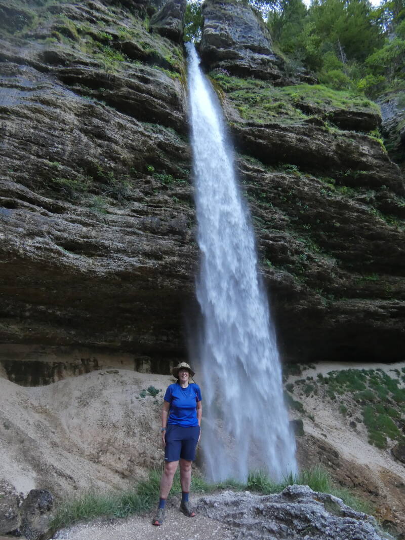
Today I finally leave the Soca River behind and follow the Juliana Trail into the Koritnica Valley. I leave the village and follow a cart track along the fields, with the Koritnica River a short distance away and a striking, sharp peak on the horizon. After a cart track through the forest, there's a pleasant stone path to a short suspension bridge that meanders over a narrow gorge, where clear blue water squeezes between the rocks. I climb a staircase and emerge at the foot of Fort Kluze, built in 1880 by the Austrians and surviving the First World War unscathed. I cross the road and pass beneath an impressive cliff complete with a large cavern, arriving at a concrete tunnel under another fort. Or is this bunker also part of Fort Kluze? As I step inside, the light comes on. The floor is rocky and uneven. A side tunnel is slightly brighter and leads to a room with a loophole. A second side tunnel is the same. My eyes keep having to adjust to the slightly dimmer light in the main tunnel, and then it suddenly goes completely dark. Apparently, there's a timer on the light, and it's expired. Luckily, I'm almost at the exit by then, and I can step back into daylight. The route runs through beautiful forests, and I'm starting to feel like a swim, but the path is high above the river. It's beautiful and green, and I enjoy it. A little later, I arrive at the Moznica, a tributary that flows into the Koritnica. There, I rest right by the water on a sandy beach and, after eating some granola bars, briefly submerge myself in the water. It's freezing cold, as always, so I don't last long. After I start hiking again I climb along the water, veering off the trail briefly when the Moznica slap, a waterfall is signposted. It's only a short distance off trail, but the waterfall is fairly high, and it's beautiful. A narrow gorge, fresh green and gray rocks and that brilliant blue water. And wonderfully cool, of course. Definitely worth it. The path continues steeply upwards over brown, dead leaves, where the sunlight casts warm patches. And then I arrive at the Moznica gorge that the guidebook promised for today. White, roaring water squeezes in between the narrow rocks, worn into a semicircular shape by the wear and tear inflicted by the stones carried over the centuries. It's a work of art. So incredibly beautiful. And this time, no entrance fee, no tourists, but a gorge in the middle of the forest for anyone who takes the time to seek it out. I end up on a gravel path that leads me to a long, sprawling village, Log pod Mangartom. One of the meadows is a landing site for paragliders, the kind you see a lot of here. The village is situated almost at the end of the valley, and impressive gray mountains rise on the horizon. I walk on to the hotel, where a pizzeria terrace invites you for a long lunch. The hostel is the building next door and doesn't open until 4 p.m. It's a nice enough hostel in itself, though it feels more like an old monastery, but the wiring leaves much to be desired. The outlets are halfway out of the wall, and wires are exposed. But the building is still standing, so I assume it won't burn down tonight. That would be quite a coincidence.
Day 9: Log pod Mangertom – Tarvisio, 22 km
After a wonderful night's sleep and a delicious breakfast at the hostel, I set off around 8:00 a.m. I cross the bridge and have to look carefully. The path veers off into someone's backyard, where it dips into the woods between the house and the barns. And then the climbing begins.Up and up and up. For about two kilometers. This first climb is about 350 meters, followed by another 200 meters or so up to the Predil Pass, which marks the border with Italy. I'm grateful for my ice towel, although after a while it's simply dry and no longer cool. I sweat and hoist myself up by my trekking poles. There are some rocky paths, but most of it is just forest, and the shade is nice. The road to the Predil Pass isn't very far, and every now and then I hear cars, but thankfully the route stays in nature. It's quite challenging. After a while, I come to a slightly wider path lined with sheep, and the route descends slightly. The Zaroenca waterfall isn't directly on the trail, but it's not far from it either. I set down my backpack on a beautiful patch of grass and walk over the round stones to the edge of the enormous cliff where the water cascades down in a narrow ribbon. Absolutely beautiful. There's no deep pool at the bottom of the waterfall, and swimming isn't an option, but I do take off my shirt and dunk it in the water until it's soaking wet. My skin is a little startled when I put it back on, but afterward, it's wonderfully cool. Hopefully, it stays that way for an hour or so, because it's quite warm again. After a short break, I continue, and the path remains fairly flat and green. After a while, I hear children's voices, laughing and playing, and again a yellow signpost indicates a waterfall. Through the trees, I see that it's more of a wide pool than an actual waterfall, and I continue on, a pleasant path between low bushes. And then begins the final climb through a meadow and past a barn to the asphalt road. It's tough. It's hot. It's steep. But finally, the soles of my shoes are touching tarmac. Not yet at the pass, but not that far away either. I almost forget to look back, but when I do, I have a beautiful view of the green mountains with gray-blue peaks behind them. I leave the panorama behind me and continue walking towards the border. The customs buildings are still recognizable, a restaurant closed. At the border, there's a marker pointing towards Italy. I don't yet know that it will be the last. I follow the road down past a gray bunker, the Battaria Sella Predil, built by Austria in 1880 to control the pass. I follow the hairpin bends downhill, carefully navigating roadworks where traffic is diverted into a single lane by a traffic light. There's a water fountain in the wall separating the lanes, and I stop for a few sips of deliciously cool water. There's a small space between the traffic and the guardrail, and despite the fact that there are quite a few cars, I don't feel unsafe. Only when a bus approaches do I briefly press myself against the guardrail. And then there's a tunnel. Oops! Luckily, there's room to walk there too. Finally, I arrive at the lake, Lago del Predil, and from the road, I see a snack bar and portable toilets. The portable toilets are locked, but the snack bar is open, and with a Coke and a bag of crisps I sink into one of the beach chairs. I take off my shoes and let my feet air out. Wonderful. The view over the lake is magnificent. Blue-green water, distant mountains, pedal boats, and a small slide. A picture. Feeling the water with my hand the temperature is actually quite nice. Unfortunately, I don't have the inner peace to actually go for a swim, although I do regret that later. When I check the guide book, it turns out the tunnel isn't on the route at all. Oops! I should have gone onto a cart track at the third hairpin, something I completely missed. Luckily, the side path to the lake is marked on the map, and the GPS tells me to go back a bit into the woods to get back to the trail. Just off the path is a large bunker, where concrete has been made to imitated a rock formation. The rusty door is off its hinges, and the stone wall that once enclosed the bunker has been broken open. Through the hole, I see the sleek lines of a corridor leading deeper into the bunker, white and surprisingly clean. I continue, climbing steeply, and soon find myself on a wide cart track. I no longer see any Juliana Trail markers, but I do see red lines on rocks, which I follow as long as they point in the right direction. After a kilometer or two, the path descends to Cave del Predil, a mining town that puts its identity on the walls of its houses, with large murals and a wooden statue of a miner serving as a public water tap. In the square, I see a small shop and buy some drinks and snacks just before they close for siesta. The route continues along the road towards Tarvisio, but according to the guidebook, there's a more attractive jeep track on the other side of the river. After a short rest, I cross the river, but if there ever was a jeep track, I can't find it. There is, however, a large mining company with locked gates. Along the outer wall are remnants of the past: narrow carts that transported materials, a small locomotive. Perhaps there was once a path behind it, but that's now blocked off with scaffolding. Back along the road then, with a tiny stream on one side running along a much larger bed, and on the other side green hills with, just off the road, a large wooden chapel with a cross in it. Two crosses have also been carved into the wooden fence. Strange. Back along the river, I notice that the water flows in the other direction. Until now, I'd always been walking upstream, but now I'm walking with the flow. Several streams flow down from the hills, and the river slowly widens. I look out for the promised cart track on the other side, but when I come across a bridge a few kilometers further, it's closed with a chain and a strict no-go sign. The guidebook is from 2023, but apparently, some things have become outdated in that short time. The route is long and not very interesting. Every now and then there are houses along the road, each with its own peculiarities, a small chapel, and always the river, now called the Rio Slizza, which flows peacefully by. At the hamlet of Plezzut, I finally leave the main road behind me. It's still asphalt, but much quieter. At a bridge, I take a break, right at the edge of the road on the asphalt. In the half hour I'm there, only one car passes. As I continue, the route climbs to the hamlet of Rutte Piccolo, where there's supposed to be an inn. At the entrance to the village, thankfully, there's another water tap with a trough, and I relievedly dip my head under the water again. When I continue to the inn, it's closed; there's no soda available. But I'm refreshed and ready for the last few kilometers. A little further on, there's a cart track through the meadows that ends at a pasture. And there I completely lose the route. There are some tracks in the grass, but they lead nowhere. Even with the GPS route I downloaded from the internet, I can't figure it out. I walk straight through the bushes, with half an eye on the GPS. It's a good thing I'm not sensitive to nettles, otherwise I'd be struggling in my shorts. Finally, I emerge into a wild grassy field from which I can see Tarvisio. A little lower, I see houses. And houses mean a road. I give up trying to find the official route and walk towards the houses. The wild grass gives way to a short-mown lawn, and a moment later, I'm back on the asphalt, relieved. I follow the road down to a larger road. And there I have to make a choice. The route is to the right, my hotel to the left. I choose left and walk into Tarvisio, which is a very long village. And now my hotel is right at the other end of it. That means another 1.5 km walk, and it's already been such a long day. Fortunately, I do pass a supermarket, where I immediately stock up on milk, yogurt, and sandwiches. Delicious. Finally, the hotel isn't that far away, and the cold shower is very nice.

Day 10: Tarvisio – Kranjska Gora, 20 km
I have to endure twelve kilometers of bike path today, and it's indeed as boring as it sounds. From the hotel, I walk back to the central square where, according to the guidebook, this stage begins. A podium is being set up, and I see no markings. There's an official route, but the guide advises me to return to the bike path that bisects the city, an old railway line, the Tarvisio – Ljubljana railway, opened in 1870. In the center of the city is the old station, with its platform slightly elevated. Further on, there's a second station in a suburb. Only the iron staircase over the tracks remains, completely overgrown on one side with trees and shrubs. I cross the Slizza River and then rejoin the official route. It's a Sunday, and there are many cyclists out and about, on both regular and electric mountain bikes. The bike path is somewhat shaded, but it remains warm. The kilometers pass slowly. I'm glad I have my ice towel, even though it's long since dried. After a campervan parking area—you can hardly call it a campsite—I discover a small restaurant on the edge of a hamlet. Although a banner announces they're open, the building is still dark and closed. Fortunately, there's a bench in the shade of some birch trees, and I settle down comfortably. After about half an hour, I continue on, and only a few kilometers later do I realize I've lost my ice towel. That's a bummer, especially in this heat. I don't feel like walking back because I'm not sure where I lost it. A sign indicates it's another 2 km to the border, and I'm looking forward to that. I've missed the Juliana Trail markers quite a bit over the past two days, and I hope they'll reappear across the border. And indeed, just past the border sign, where many cyclists stop for photos, the familiar yellow signpost and orange paint markings on the road reappear. I walk to Ratece and follow the markers through a village and across the road. And there I lose my way again. I'm still heading in the right direction, but now I arrive at the back of the forest where the guidebook recommends the side path to the Zelenci Nature Reserve. I walk back and then take a detour to a small but special lake. While the rivers were already impressively clear, this lake takes it even further. Crystal-clear water where you can not only see fish swimming, but also their shadows on the bottom. The grass around it, the mountains in the background. It's magnificent. There's a small observation tower where you can see the lake from a different perspective, and that's also very beautiful. After another half-hour rest, I walk back through the forest, following the official route this time. At a small restaurant, I stop for another longer break for a delicious, homemade, warm apple strudel and a Coke. It's a lazy day today. When I go to Podkoren, I see the large racks in the landscape for the first time. Concrete poles with wooden poles in between. At first, I'm not sure what they're for, but then I see hay hanging out to dry in another one. Remarkable! The route is quiet and rural, and I'm enjoying it. Finally, I see Kranjska Gora looming, which is much larger than I thought. I cross the stream, a road, and enter the village. At the bus stop, I veer off the route to go to my apartment, which is near a supermarket and has a small kitchenette. After showering and dropping off my luggage, I walk into town, but despite the three outdoor shops, they've never heard of an ice towel.
Day 11: Kranjska Gora – Mojstrana + Pericnik Falls, 19 km + 6 km
It's not often I have so much trouble finding the route. From the apartment, I walk back to the bus station, where I follow the waymarkers to the Tourist Information Center. And there they disappear again. I have no idea how to proceed. I grab the GPS and it turns out I have to go back to the small river at the edge of town. I walk back to the bus station and indeed, there's a yellow signpost that I completely missed. I follow the route to the end of the street and there... nothing. Finally, I walk back to the bridge where I entered the town yesterday. It's not quite the official route, but I'm sure it will be added later. And indeed, a little further on, the route joins from the right and the waymarkers continue along the river. The route is nice, along the river, through the woods, and past a house with a large water wheel. I climb quite high and emerge into open fields, where I have a magnificent view of a group of impressive gray peaks. I think this is the famous Martuljek Group, the one the guidebook mentioned? At 2,472 meters high, Spik is the most prominent peak, but honestly, the whole group is impressive. They rise sharply and angularly above the hills, magnificent. Eventually, I arrive at the village of Srednji vrh, where a beautifully decorated chapel stands. It's not the Marian chapel known in the Netherlands, but a square column with a wooden slate roof, painted on all sides. Each side has a niche with a painting or statue of the Virgin Mary. You see more of them along the way, but this one surpasses all the previous ones in beauty. From here, I follow a paved road downward, a short tunnel through the rocks, so short that it's more like a long rock arch. Just before reaching the village, I take a break. Where I used to walk all day until I could no longer, I'm getting better and better at resting when my body demands it. It's relaxing, and I enjoy the route more this way. I reach Gozd Mrtuljek, where I cross the Sava Dolinka again, which has now grown considerably. Passing between a few houses, I turn off towards the lower Martuljek Falls, a low waterfall cascading down a retention wall that ultimately proves not to be all that impressive. Since the trail makes a detour specifically for this purpose, I expected a bit more. Then the route returns to the bike path, which runs very close to the busy road. It's hot, and the route is a bit dull. At a picnic table, I pick up the guidebook. It suggests an alternative route that stays on the other side of the river and looks much greener. My GPS follows the bike path, but the Juliana Trail app also follows it. Fortunately, the guidebok suggests another alternative a little further on, and with the GPS, I manage to find it. It's a beautiful route through fields and later through the forest, right along the river, so now it's a large boulder field where I can't even see the water. At the edge of Mojstrana, I emerge from the forest, and the route loops all the way around the village to the other side, where the tourist information center is located. But what catches my eye is the vending machine next door, filled with cheese, yogurt, and, to my great delight, deliciously cold milk. I buy a liter and down half of it almost immediately. I walk along the road to the hostel, which is one of the most beautiful I've seen in Slovenia, both inside and out. It feels homely, very cozy.
It's still early, so I rest. In the late afternoon, I set off with one of my roommates for a trip to the Pericnik Waterfall. We walk back to the TIC and cross a bridge over the Triglavska Bistrica River. We follow the water upstream, generally on good forest paths, but there's also a stretch of eroded bank where only a narrow, sandy path remains. Definitely not a path for walking in sandals. Then we cross the river again and walk along the road to a white hut, where we see several cars parked. A staircase leads into the forest, and from afar we feel the coolness of the water. And then we see the waterfall, a long white ribbon cascading down from a high rock. It's so clear that I can barely photograph it in its entirety. It's beautiful. In the rocks, you can also see the rounded shapes where the waterfall used to be. The water has shifted twice, and two semicircularly eroded rocks are now dry. Very special. But the most beautiful part is the path behind the waterfall. On the way there, it feels like rain, tiny droplets on my head, while I protect my camera with my hand. The path is sandy, but wide enough to pass the tourists on the way back. Super nice. On the other side is a viewpoint where we have another beautiful view of the waterfall. My roommate starts chatting with a couple of tourists, and they offer us a lift back to the village. Wow, that saves us a 6 km walk back. Wonderful.
Day 12: Mojstrana – Jesenice, 21 km
The day begins with a climb to Dovje, a small village with colorful houses. Soon after, I reach a gravel road that climbs gradually. It's a long road, about 8 km, and there are no waymarkers. I pause at a bridge, then continue. Some fields and farms appear. At one of them, there's a trough with a tap, and I walk down to wet my head. Someone has put beer cans in the trough to keep them cool. About a kilometer and a half earlier than expected, the gravel road descends again, and I've had the worst of the climb. At a few houses, I step onto a paved road that I follow downwards, and in Plavski Rovt, I briefly rest under a tree for a Coke I still had with me. From there, the path leads into the fields, and the grass retains the heat well. I really miss my ice towel; it would have come in handy right now. Signs remind hikers to stay on the path, close gates, and keep dogs on a leash—the first I've seen along the way. At Planina pod Golico, I cross the Jesenice River, and shortly after, thankfully, the cool forest reappears. A small chapel is dedicated to St. Barbara, the patron saint of miners. An information board explains the history of mining in this area. Ore was brought from the mountains to Jesenice in small carts drawn by oxen. This section of the path was the steepest, so the rear wheels were removed so that friction with the rocks would slow the carts down. And indeed, a perfectly straight indentation can be seen in the rocks on the path. How remarkable. I descend to the outskirts of Jesenice, where I had expected to go straight into town. I've since discovered that my accommodation isn't 3 km from the center, as booking.com promised, but a full 9 km. Therefore, I need a taxi, and where better to find one than at the train station? I deviate from my route and walk to the station, but no taxi. Luckily, there's a taxi company's business card at the counter, and after half an hour, the taxi arrives. An older man complains about the lack of work and how everything was better under Tito. The accommodation turns out to be a mountain hut, and those nine kilometers are all uphill. I'm glad I don't have to walk them. I make things easy for myself and arrange with the taxi to pick me up again tomorrow. So, a reasonably cheap stay suddenly becomes very expensive.
Day 13: Jesenice – Begunje, 18 km
This might be my least favorite leg of the entire trail. The guidebook recommends skipping part of the route and taking the train to Vintgar. But stubborn as I am, I want to walk the entire route without cheating. The taxi drops me off at the station, and I walk back to the official route. I cross the railway to a small shopping center with a supermarket and an outdoor store (no ice towel), and then have to search for the next part of the route. The GPS route I downloaded online, which I now know isn't very reliable, points me to the other side of the river. Eventually, I see markers that lead me to a drab neighborhood and later a gravel path behind the houses. At a suburb, I finally cross the river and walk along a busy road out of town. The road and the speeding cars make me uneasy and stressed. The noise, the exhaust fumes, the haste. Not for me. At Lipice, the trail turns onto a side road, through a sleepy village, and then crosses the A2 highway. A relatively quiet section follows through the fields. That doesn't last long. The trail returns to the highway, crosses a dam, and climbs up to Zirovnica. There, I take a pleasant hour's rest at a café, drink a lot of Coke, and eat a delicious strudel. Continuing on, I follow the road until I'm finally directed into a meadow. Another hiker sits reading under a tree. In the distance, the sky darkens and a rumble begins. At the edge of the forest, at a junction, there are no longer any markings. A signpost for Begunje points to the right, towards a village, but the Juliana Trail logo is missing. I grab my GPS and see that if I enter the forest here, I'll eventually end up back on the official route. Hmmm… forest or more asphalt and roads, an easy choice. I choose the forest, of course. I keep an eye on the route and enjoy the cool shade. It's a steep climb over forest paths and the occasional rockfall. Eventually, I rejoin the route and keep climbing. The rumbling gets closer, and I start to get restless. It starts to drizzle, and I put my camera away. Then I arrive at the Sanskaska Koca hut. On the terrace, the chairs are leaned inhospitably against the tables, but the kitchen window is open, and I buy a delicious Coke. From the terrace, I also have a wonderful view of the valley: greenery, mountains, and dark clouds on the other side. From here, it's a bit of a climb to a beautiful church perched just on the edge of the mountain, beautifully contrasting with the dark valley. And then it's downhill, long and steep, all the way to Begunje.
Day 14: Begunje – Bled, 15 km
According to the guidebook, Ravodljica is one of the most beautiful villages on the route. I'm not sure I agree. You walk along the foot of the castle walls, but I don't see much of the castle itself. The tunnels under the thick city walls are quite impressive, though. The square with houses from the 16th to the 18th century looks rather shabby. I walk out of town to a viewpoint overlooking the valley and the road down to the railway. There begins a path along the Sava Dolinka River, which is very beautiful and green. On the river, I see yellow boats coming from Bled, full of tourists using their paddles to splash each other before entering the rapids. Apparently, a lot of Dutch people come to a huge campsite, because the information board about tent rentals is in Dutch, and there's even a Dutch campsite owner present. At the back of the campsite is a bridge, and the route continues along the shore to a paved road that goes directly to Bled. In the far distance, I can see the castle in the hills above the town. The route is marked with a signposted signpost, the Tourist Information Office, but since my hostel is in the other direction, I continue along the route towards Lake Blejsko. The route doesn't run right along the water, but a path a little deeper into the park, which I completely disagree with. I want to walk along the water, and so I do. The view of the lake is beautiful: a small island in the middle with a church on it, the hills, the crystal-clear water. There are hefty fines for swimming, so I don't dare try it here. When the path bends towards the castle, I leave it in front of my hostel. There I rest for a few hours before starting today's second adventure: Vintgar Gorge. There are free shuttles from the bus station, and I'm a bit early for the 6:00 PM time slot. When we're allowed in, we're first given helmets, which you really only need if you're over 1.80 meters tall. Because it's quite late, I soon have the gorge almost entirely to myself. The other tourists walk ahead, and I can watch and film to my heart's content. And this gorge is beautiful! Narrow with countless rapids where the white water swirls over the rocks. Wooden planks over the water. I see a dipper and take so many pictures, it's almost more fun than the gorge itself. At the end of the gorge, I walk through the turnstile and return my helmet. I buy an ice cream and choose the short route back to the parking lot where the shuttle will pick us up again. It's quite a distance through the forest, with a steep hill in between, and I'm impatient. The last free shuttle leaves at 8 p.m. Luckily, I just make it, but I wouldn’t had I taken the long route. There's some confusion about who goes where, because there are also two parking lots where a larger bus goes. Eventually, another hiker and I get into a smaller bus, which later picks up two more hikers who did take the long route.
Day 15: Bled – Goreljek na Pokljuki, 22 km
From the hostel, I walk back to Lake Bled, where the water glitters blue and the hills glow green in the morning sun. The path skirts the base of a hill, and there are a surprising number of runners out and about, now that it's still cool. I climb a steep path and some stairs to a railway line and Bled Jezo. The route is paved and runs from one village to the next, with views of vast fields in between. In the villages, there are the usual water points and chapels, of which you see many in Slovenia. Barges have their sides painted with saints, and St. George and the dragon are particularly popular. Because it's Sunday, the supermarkets are closed, and I have to make do with the water and mango juice I have with me. At Krnica, I'm finally allowed to leave the road, and the trail becomes a bit wilder. A forest path leads me to a parking lot, the start of a hike to the Pokljuka Gorge. I use the restroom and then settle down on a bench, as it's already quite warm. A taxi drops off two hikers who are asking for directions to the gorge, and I point them to the sign nailed to a tree, clearly pointing to a path between low bushes. The path starts out gentle and flat, but quickly becomes uneven and stony. Combined with the climb, this makes the hike challenging. A little later, there's a fork in the road. Before the gorge itself, you turn left, but the Juliana Trail bends to the left. This doesn't make the trail any less spectacular. A little later, I'm standing at the foot of a huge rock arch, which looks more like an open cave. The path goes right through it—fantastic. I've really missed that these past few days. Nature, wilderness, and unspoiled greenery. I'm starting to worry a bit about my water. I started the day with 2.5 liters as usual, and I still have a liter of water, half a liter of mango juice, and a can of Coca-Cola left. That should be enough, but since the weather is hot and dry, I'd rather be safe than sorry. Fortunately, the shade offers some coolness, and it's not so extremely hot anymore. I cross a road, and shortly after, the route bends to the right. My gut tells me this isn't right. I check the GPS and it turns out I'm indeed slightly off course. I don't remember missing a marker, but I was unsure whether to take this path or the one slightly parallel to it. I backtrack a bit and, with the help of the GPS, quickly find the right route again. Today, I also discover the elevation gain on my smartwatch for the first time. Until now, I'd only used it to measure distance and my average pace, but today, for the first time, I'm pleased to know I only have another 200 meters of climbing to do. A wide, rocky forest path leads me to a steep step into a meadow; in the distance, a small house and a barn stand. On the other side of the meadow, there's more forest, and this time the path is beautiful and green, with calf-high grasses growing among the pines and conifers. I also come across wild strawberries, with small red berries. I gather a handful, and although they're not sweet, they're very tasty. A little later, I come to a small hut with a bench, which the owners of the house across the street have built for hikers. A lovely place to take a break, though I quickly lie down in the grass in front of it. A woman is mowing a huge field with a small lawnmower; the sound cuts through the forest. At the edge of the field, ornately decorated wooden signposts point to Triglav, Stara Pokljuka, and Bled. Hiking enthusiasts live here, that's for sure. I still have a liter of water left, so with only 6 km to go to the hotel, I should be fine. It's cloudy, so it's not so warm anymore. I continue walking through a large valley with a barn and a house where a family is having a pleasant lunch. On the other side, I step onto a gravel road and, despite the clear markings, I suddenly go the wrong way. Luckily, I check myself shortly after and quickly realize this, so I don't go too far in the wrong direction. I follow the gravel road for a few kilometers until I come across a sign for Planinka Zajavornik, under which a few cars are parked. For a moment, I think this is the hotel, but that's too early. Fortunately, it's something that makes me even more happy: a farm shop with a terrace. It's a whole complex with small huts and a nice terrace in front of the main house. Several hikers and cyclists are already there, and I plop down on one of the benches. A little later, I have a Coke and a glass of milk in front of me and only later realize that the milk was probably raw and unpasteurized. Oops! Oh well, I'll probably survive this one. The hostess explains that they're only open in the summer because the cows graze here and need to be milked. I'm glad I did, anyway. Even though it wasn't long after lunch, I still enjoy relaxing here for a bit. After about an hour, I head back to the trail, which runs right across the land. It's very windy, but luckily I quickly find myself back in the woods, where I don't feel the wind. I meet two Dutch people who do day hikes and have their car parked at the hotel. Together, we walk the last bit through the woods and a short distance along the road to the hotel. There I relax and after dinner I use the sauna. It's a real 80 degrees, and with the towels from the room, I can stretch out in front of the stove. Wonderful!

Day 16: Goreljek na Pokljuki - Bohinjska Bistrica, 33 km
I wake up to the steady sound of rain. This isn't a short shower, but a heavy one. This is rain that lasts for hours. And this on the longest day, where I'm connecting two stages. Fortunately, it's mostly downhill to Stara Fuzina, and from there it should be flat to Bohinjska Bistrica. I turn over and get dressed for breakfast an hour later. When I set off, the rain has turned into a drizzle that I barely notice, and hopefully it stays that way.
I walk back to the road and descend to a hamlet with a few houses and a monument made up of rifles, helmets, and other military equipment. I dive into a puddle-ridden forest path and, a little later, turn a signpost that some thief had twisted in the right direction. I pass a village with small houses in a large, open field, and then another forest, where I carefully navigate my way around the large puddles. The waymarking on this section is perfect. The yellow signs are accompanied by white JA diamonds on the trees, which are lavishly applied. There's no chance of going wrong here. At the edge of the forest, the route crosses meadows of short grass, with beautiful views of the hills draped with wisps of cloud, with the occasional house in the foreground. It's beautiful. It's also dried up, and precisely because the sun isn't shining, it remains wonderful walking weather. I cross villages and fields, walking along bits of road and grass. And then suddenly I see a fox running in the field. Much too far away to film, but I bring it closer with my camera. What a lovely sight. Aside from lizards, I haven't seen much wildlife in Slovenia. This makes my day. The route remains beautiful, with alternating forest and grass paths, flowers, and mud. Then I come to a chapel with an information board and read about mining in the region. Ore was brought down from the hills along this path, and because it was steep, they took the back wheels off the cart. The axle scraped against the rocks, slowing the cart down. And indeed, I see a perfectly straight groove in a series of consecutive rocks. How remarkable that history is still so clearly visible in the landscape. Shortly after, a steep descent begins; the hairpin bends of the road are cut off by a stony footpath that plunges straight down. It's not very fast, but it's much more enjoyable than the asphalt. After 13 km, I take a short break in Jerika, where I sit on a wall near a house. The path becomes easier, and I cross a river at a bridge. On the horizon, an impressively steep mountain appears, completely dominating the landscape, and it seems the route will bring me even closer. My feet are impatient, and I stride briskly along the bike path between the fields. At a ski resort, the restrooms are open even though the ski lift is standing idle, and I gratefully make use of them. In Srednja vas v Bohinju, I lose my way again. I walk along the road towards that fascinating mountain, where I suspect Stara Fuzina lies at its foot. It also looks like it's raining there; gray clouds hang low over the other valley. Then I realize I should have goneto the right somewhere almost a village ago. This causes me to skip a small hamlet, but with the GPS, I see a path where the two roads almost meet again. I walk a bit further and then turn off onto the official route. That's just in time to reach a green path that leads to Stara Fuzina. There, at the edge of the village, I stop to pet a cat, and afterward, I think I lost my hat somewhere there, because when I watch the videos later, I no longer have it around my neck when I enter the village. I walk into the village and, near a bridge, there's a restaurant where I discover pancakes on the menu. They were actually meant for dessert, but they make a great lunch. As I continue walking, I descend to a beautiful lake, Bohinjsko jezero, or Lake Bohinj. Although it's not very sunny, there are still people swimming. I'm not tempted. I continue walking along the lake until it starts to drizzle. And just as I try to put on the hat that had kept my glasses so dry, I miss. No hat. Maybe I left it at the restaurant? The restaurant is 20 minutes away, and I don't feel like walking back and forth for almost an hour. I put on my raincoat and walk on to Ribcev Laz. There I come across a bike rental shop, and oh well, go for it. I rent a bike for an hour, put my camera in a locker, and cycle back to the restaurant in Stara Fuzina. Unfortunately, they didn't find a hat at the restaurant. Bummer! It wasn't sentimental, but I was still happy with it. I cycle back, put my backpack back on, and continue on, through the village, which is busy and touristy, and into a quieter side street. Outside the village, there are pleasant gravel paths and woods, but it starts to drizzle, and that makes me miss my hat even more. At least I'm no longer complaining about losing my ice towel. I put on my raincoat and continue walking into the hills. A little later, the weather clears up, and I reach the open field, from where I have a fantastic view of the beautiful landscape of high hills, mountains, and conifers. It's still quite a distance to Bohinjstra Bistrica, but eventually, I see a village appear through the trees. Luckily, the hostel is on the edge of it, so I don't have to walk too far. I just pop into the supermarket and, after a moment's hesitation, I finally enter the outdoor store across the street. They don't have any hats and are considerably more expensive than the shop in Bovec, but I do end up buying a cap with a neck protector. Not for the sun, but mainly for the rain that's forecast for tomorrow.
Day 17: Bohinjska Bistrica – Trtnik, 16 km
I walk out of town past a sawmill where the logs are piled high and the smell of freshly sawn wood makes me inhale deeply. Wonderful. The route delves into the forest on an old gravel path and it starts to drizzle. When it enters the open field, I decide to put on my raincoat and the cap that keeps my glasses dry. At first, the rain isn't too bad, although I hear it rumbling in the distance. After Nemski Rivt, a village full of gray houses, the route enters the forest again and starts to climb. This time, no easy, wide paths, but real, pleasant forest trails full of roots and rocks. The rain starts to come down harder, and I cross a meadow to rest on the veranda of a farmhouse and think for a moment. The rumbling is still going, and every now and then I see a flash of lightning. Is it safe to continue? Looking at the route, I'm nowhere above the treeline, and although you shouldn't take shelter under trees during a thunderstorm, I estimate the chance of me being hit is low. After a short stop, I step back into the rain. It's a shame, because this is precisely where the route is incredibly wet. Fields of tall grass and flowers. I emerge onto a gravel road, which I follow for a while, which I don't mind, because I have a total of 770 meters to climb today, and a gravel road is quite easy. The weather is also getting lighter, and I suspect I'm approaching the end of the valley and the rain will be contained to one valley again. Just at the turnoff where the Juliana Trail heads into the mountains, there's a small wooden hut. The front door is padlocked, but I'm dry on the small veranda, and it's a nice spot for another short break. The rain has also dried up, which makes the last 100 meters through the forest to the summit much more pleasant. At the pass, there's a red signpost with numerous routes. Two hours to Podbrdo? That should be doable. Just below the pass on the other side of the mountain is a hut where two Belgians are swapping their wet clothes for dry ones. They're walking the Juliana Trail in the opposite direction, with a tent, and are therefore considerably more heavily loaded. We exchange information, and then I begin the long descent through the forest. The mountain is so steep that retention walls have been built, and eventually the path merges into a very old, barely recognizable jeep track. Between two barns, I return to the asphalt and walk to a church that stands alone on a narrow hill. I walk down past the church, ignoring the watering cans in the cemetery. In the distance, I see Podbrdo, a small village with a church at its center. There's a bar there, where I work on my videos for a few hours while I wait to check into my accommodation. When I look it up on Google Maps, it turns out to be in Trtnik, about 3 km further on. Fortunately, it's on the route, so I can shave off some of tomorrow's stage. I stop at the small supermarket for milk, yogurt, and some snacks, then walk out of Podbrdo and up a hill to Trtnik. The route follows a paved road, but then cuts a hairpin bend through the grass, dropping me right in the village and back at my accommodation.
Day 18: Trtnik – Grahovo ob Baci, 17 km
This might be one of my favorite days on the Juliana Trail. Straight from the accommodation, I step down a small staircase into a meadow. Not a flat meadow, it's a hill, and incredibly steep too. For the first time on this hike, I feel my calves protesting and cramping. The ascent is slow, step by step. Even in the forest, the trail climbs steeply. There's a stretch of gravel road, and when the waymarker points into the green, I'm initially happy. But the path is so eroded that it's barely safe anymore, and as a hiker, it's better to stay on the gravel road. The mountains on the other side are beautiful, but when I reach the saddle, I'm still surrounded by trees and there's no view. The trail continues downward. There's a small village with the usual water tap and a path through the meadows where I briefly lose track because the grass obscures the waymarker on a rock. The path leads down into a forest, where I walk along a dark ravine. Not very deep, but pleasantly cool. I continue on a paved road, directly in the sun, and although the heatwave is over, it's still quite warm. A little later, there's an old cart track leading past a ruin. It's an easy walk in the shade of the trees. This seems to be the section with the least amount of asphalt, and I thoroughly enjoy it. The waymarking is also flawless, and it's much easier to walk without constantly having to check my GPS. Finally, I descend to the Baca River, with water such as I've only encountered in Slovenia so far. Several picnic areas have been created along the riverbank, and at one of them, I see a climbing frame, a picnic bench, and an iron lounger. It's too tempting. I take off my backpack and lie comfortably in the lounger for half an hour, listening to the rippling water. As I continue, I'm so relaxed that I only now realize how tense I was before. Apparently, I still have certain expectations of myself, about how fast I should walk, how long a stage will take. After this rest, I've completely let go of those worries, and it feels wonderful. Further along the river. Between two stone walls, I enter Koritnica, a name that sounds familiar. Didn't I enter the Koritnica Valley after Bovec? Now I'm on the other side. I follow the river down to the center of Grahovo ob Baci. There, I leave the trail to go to my accommodation, which is about 1.5 km outside the village. The guidebook indicates there should be a small shop in the village, but that turns out to be incorrect. Luckily, the guesthouse has stepped in and sells drinks and snacks. Not only that, but it's also incredibly luxurious. A comfortable bed, a good shower, and a balcony where I can dry my shirt and enjoy the sun. The guesthouse provides both dinner and breakfast, so I don't have to do anything else myself.

Day 19: Gahovo ob Baci – Tolmin, 28
After a hearty, restaurant-quality breakfast in the luxurious guesthouse, I strap on my backpack for the last day on the Juliana Trail. The kilometer and a half back to the trail flies by much faster than yesterday, and in a flash, I'm back at the bus stop where I left the trail yesterday. The route begins climbing almost immediately, first through a few streets and then a concrete path between the meadows. I can feel my calves protesting, and my Achilles tendons have become quite stiff in recent weeks. Despite the early hours, it's already quite warm, and beads of sweat are soon forming on my forehead. Fortunately, I soon find myself in the woods, where an old cart track winds along the hills. Just in front of a house, a picture of a golden retriever hangs along the path with the message "friendly dog." A bend later, I see a house and the dog comes running, barking, but its tail is wagging, and after sufficiently intimidating that pesky intruder, the smells in the grass are much more interesting. The route winds past a collapsed house. The doors are still hanging in their frames, a mattress is already old and moldy, and a coat still hangs on a closet. It's been a while, but the house is still in the transition phase from recognizable as a residence to complete ruin. I descend to a village where the road is under construction. I glance at the GPS and then walk around the church to get back on the route. From here, I walk quite a bit on the road, which I don't mind at all. After all, it's going to be a long hike today. Then I see a large wooden sign along the road announcing the Sopot Slap, the Sopot waterfall. The guidebook had already warned me that this is one you definitely don't want to miss. Barely 10 minutes from the trail, the water cascades 62 meters down the rocks in three stages. Of course, I have to see it. I follow the path up, over wooden steps and soft forest floor. I'm leaning heavily on my trekking poles, because it's a steep climb. Fortunately, it's not far, and after about 300 meters, I hear the rush of water. And yes, the waterfall is just as impressive as the guidebook promised. Not so much the volume, but rather a thin wispy stream of water that swirls down like a veil. The lowest rock is slimy, countless shades of brown and black. Above it, the sun caresses the water as it falls over the second rock, and it sparkles so brightly that it's hard to capture it in a single photo. The pool at the bottom of the waterfall is crystal clear, turquoise, and wonderfully cool. If it were warmer, I'd jump in right away. While two German children clamber over the rocks while their overly concerned parents look on, I take a moment to relax on a bench. But after fifteen minutes, I put my backpack back on, aware that I've linked two stages together today to reach the end in one go. I descend again, and in the last patch of grass before reaching the road, a large snake just crawls away. I'd caught a glimpse of one before in Slovenia, but now I really see it. Unfortunately, it disappears again very quickly, what a shame. I continue my path along the road and get a beautiful view of the valley and the hills on the other side, where the sun casts yellow flecks on the fields. Along the way, impressive rocks appear, resembling concrete, a structure of gray grit. Strange. I stop briefly at a drinking trough where crystal-clear water flows from a hose. Two drinking cups are attached to the trough with chains, and I shake the leaves out before holding one under the hose. I also dip my new cap into the trough; my hair is already dry after the cemetery, and it's so warm that I'll take any chance to cool off. After reaching the highest point, I descend quite steeply through sheep pastures to Ljubinj, but before I reach the village, there's a gravel road and the climb to the Senica viewpoint begins. Although the route follows the gravel road almost all the way to the top, the climb shouldn't be underestimated. It's challenging. A jeep trying to reach the summit was stopped by a large tree across the road. High enough to walk under, but not so high that the jeep can pass under it without damage. According to the red signs, it should take about 40 minutes to reach the top, but that's probably only for Slovenian mountain goats. It takes me longer.
The last five minutes thankfully pass through the forest again. I welcome the shade, and my legs enjoy the peace now that the climb is over. And then there's the viewpoint, and a magnificent panorama unfolds before me. The viewpoint lies at the intersection of two valleys. On the left, I see Most na Soci, and in the valley on the right, I suspect Tolmin. I recognize the church with the candle vending machine and the cemetery on the edge of town. Both towns are situated on beautiful, milky-blue waters, with a single, large, green hill between them. It's magnificent. This time, I'm taking a lunch break and can't get enough of the view. Even better is that I'm alone and don't have to share this moment with anyone. No chatter or shrill children's voices. It's so incredibly peaceful. Wonderful. Only a thumping noise drifts up from Tolmin. There's some kind of event going on, a rave I hear later, and it's audible.
After a wonderful break, I set off again, refreshed and energized. But if I thought the climbing was over, I was disappointed. There's a narrow path between the rocks, and I see mysterious holes in the mountain. Old bunkers? According to the guide, Austrian troops were stationed here in WWI, but they never took part in the fighting on the Isonzo Front. Then the descent really begins. The path is rocky, and going down isn't as fast as you'd think. Lower down, there's gravel and stones, and that doesn't make much progress either. Eventually, I return to the asphalt and walk towards Modrej. But before I enter the village, the route turns off towards Most na Soci. Once again, the GPS confuses me. The route I downloaded from the internet stays on the right bank and heads towards Tolmin, but the waymarks turn left to reach the left bank of the Soca River. I already knew the route wasn't very reliable and decided to follow the waymarks. The GPS route in the Juliana Trail app doesn't exactly follow the waymarks, but sometime I have to turn left. So, on I go. A beautiful narrow path follows above Modrej, past fields and allotments, and so I arrive above Most na Soci. There are plenty of bars and restaurants here, but I don't feel like sitting around for long, so I buy a drink and a snack at the gas station. I follow the path under a house to the lakeshore and plant my backside on a jetty for a short break. Well, short. The view is so beautiful, I can't stop looking at it. The water, which looked so pure from a distance, is intense, milky blue, covered in twigs and leaves. The hills surround the water like a bowl, undulating and green. The houses look like jewels in a noblewoman's hair. It's a picture. After a nice, lazy break, I walk around the lake until I enter the forest again at Modrejce. The path skirts the 510-meter-high Bucenica, the mountain that separates the two valleys. It's a lovely walk, but the party boat on the river, loudly hurling music into the valley, irritates me. Further on, closer to Tolmin, I hear the loud thumping. It turns out there's a rave going on. The noise irritates me; this isn't how I imagined the end of my walk. Fortunately, the party is a bit outside Tolmin, and as I approach the town, it quiets down again. Through the trees, I see the Soca River again. There are quite a few fallen trees on the path, but luckily, I easily clamber over them. Then the descent begins. I end up on a road I recognize. I strike up a conversation with a Slovenian woman, and together we walk past the campsite to the bridge over the Soca River. On the other side, we stop at the bar. I'm not going for a swim this time; it's just too cool. When she meets an acquaintance, we say goodbye, and I walk the last few meters to town on my own, following the familiar route. Things have come full circle. I've hiked the entire Juliana Trail, and it was fantastic.
